(work on graphics in progress)
Moku Boundaries and Stars
O’ahuʻs land divisions were called Kaananiau. Ahupuaa, the name most people know, is the name land divisions that seem to have come to O’ahu with the chiefs of Maui and Hawai’i islands beginning in the last half of the eighteenth century. Kaananiau is often said to mean the (ka) beautiful (nani) time (au), but it also means the (ka) survey/measure (ana) rod (niau). The niau is a coconut leaf midrib or a rod made of ‘ilima used as a kapu or boundary marker. A kalana is a land section larger than a kaananiau, but smaller than a district/moku. Moku are the largest sections, or districts, of an island. (Moku also means island.)
Just when the lands of O’ahu were organized into moku is uncertain. What is known is that before 1778 the island had six moku. In 1891,W.D. Alexander, the Kingdomʻs Superintendant of Government Survey, wrote “A Brief History of Land Titles in the Hawaiian Kingdom,” in which he wrote, “The ancient system of land titles in the Hawaiian Islands was entirely different from that of tribal ownership prevailing in New Zealand, and from the village or communal system of Samoa, but bore a remarkable resemblance to the feudal system that prevailed in Europe during the Middle Ages. Although this system of land tenure was radically changed by the peaceful and beneficient revolution which took place during the reign of Kamehameha III, yet the ancient subdivisions of land remain unchanged to the present day.”[i]
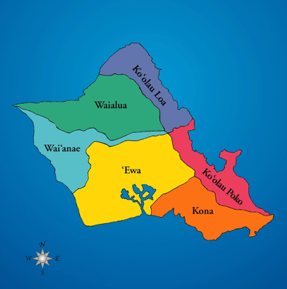
There is general agreement about the moku boundaries except for the southern end of the Ko’olaupoko and Kona moku. Below are two maps showing the moku boundaries.
On this map, from Kumukahi.org, the labels for Ko’olaupoko and Ko’olauloa are the reverse of what they should be. The Kona-Ko’olaupoko boundary places Koko Head and a portion of Maunalua Bay in Ko’olaupoko.

This map, from KSBE (Kamehameha Schools Bishop Estate) shows the Ka’olaupoko-Kona boundary placing the region from Makapuu through Maunalua Bay within the Kona moku.
The line that begins at the north shore boundary between Waialua and Ko’olauloa and continues to the sea in the southeast at the boundary between Ko’olaupoko and Kona runs along the ridge of the Ko’olau Mountain Range. It is, then, not surprising that boundary markers along this line are mountain peaks. However, the mountains that are boundary markers are also a) star rise markers from the point of view of Kūkaniloko and b) markers for the rise of stars that signal sun stations.
The illustration below shows star rise and set lines radiating from Kūkaniloko. The stars indicated are the calendar stars plus some non-calendar stars that signal sun stations.

The table below shows moku markers and that stars that rise or set over them.
| Moku Marker | Marker
Az |
Boundary
|
Star/Sun | Star/Sun
Rise/set Az |
Relationship to sun |
| Kamananui | 285-360 | Waialua/Waianae | Sun/Gemini | 293/293 | June solstice sunset |
| Puu Pane | 278 | Waianae/Waialua | Cancer | 278 | Sunset at Cancer evening rise; July solar
zenith occurs in Cancer |
| Puu Kalena | 260 | Waianae/Waialua | Regulus | 260 | Sunset at Regulus evening rise; Regulus rises
in the sun and announces highest birth |
| Puu Pueo | 287 | Waianae/Waialua | Kete/Aldebaran | 284 | May solar zenith takes place in Kete |
| Puu Pauao | 81 | Waianae/Koolauloa | Kete/Aldebaran | May solar zenith | |
| Kaoio Pt | 82 | Koolauloa/Koolaupoko/Ewa | Betelgeuse | 84 | Forerunner of June solstice |
| Koiele | 85 | Koolauloa/Koolaupoko/Ewa | Betelgeuse | 84 | Forerunner of June solstice |
| Puu Ohulehule | 86 | Koolauloa/Koolaupoko/Ewa | Betelgeuse | 84 | Forerunner of June solstice |
| Puu Manamana | 81 | Koolauloa/Koolaupoko/Ewa | Betelgeuse | 84 | Forerunner of June solstice |
| Puu Kaaumakua | 87 | Koolaupoko/Waianae/Ewa | Sun | 87 | Equinox sunrise |
| Mauna Kaala | 270 | Waianae/Waialua | Sun | 270 | Equinox sunset |
| Kahiakahoe | 118 | Ewa/Koolaupoko/Kona | Antares/Sun | 119
|
Solar nadir/December solstice sunrise |
| Puu Hapapa | 241 | Waianae/Ewa | Antares/Sun | 241
|
Solar nadir/December solstice sunset |
| Kumumau Pt | 155 | Kona/Ewa | Southern Cross | 157 | January solar nadir |
| Puu Manawahua | 209 | Kona/Ewa | Southern Cross | 205 | January solar nadir |
| Pili o Kahe | 210 | Waianae/Ewa | Canopus | 210 | Regulus rising |
| Makapuu | 119 | Koolaupoko/Kona | Antares/Sun | 119 | Solar nadir/December solstice |
Below is an annotated map showing the boundary markers.

The line between L and M indicates an alternate boundary between Kona and Koolaupoko. That boundary places the southern section, to the right of the L-M line, in Koolaupoko.
| Moku | Landscape marker | Marker bearing | Star/Event | Azimuth | |
| A | Waialua-Waianae | Kaena/Puu Pueo | 287 | Aldeberan – May zenith; Nov nadir | 284 |
| B | Waialua-Waianae | Mauna Kaala | 270 | Sun – equinoxes | 270 |
| C | Waianae-Ewa | Puu Hapapa | 241 | Antares – Nov nadir; Dec solstice | 241 |
| D | Waianae-Koolaupoko | Waimea St/Puu o Mahuka | 348/351 | Dubhe (Big Dipper) | 347/348 |
| E | Waianae-Waialua-Koolauloa | Puu Kaaumakua | 90 | Sun – equinoxes | 90 |
| F | Waianae-Ewa-Koolaupoko | Kahiakahoe | 118 | Antares – Nov nadir; Dec solstice | 119 |
| G | Koolauloa-Koolaupoko | Kaoio Pt | 82 | Betlegeuse – both solstices | 84 |
| H | Waianae-Ewa | Piliokahe | 210 | Canopus – rise of Regulus | 210 |
| I | Ewa-Kooloaupoko-Kona | Konahuanui | 122 | Antares – Nov nadir; Dec solstice | 119 |
| J | Ewa-Kona | Kumumau Pt | 155 | S. Cross – January nadirs | 157 |
| K | Koolaupoko-Kona | Makapuu | 119 | Antares – Nov nadir; Dec solstice | 119 |
| L | Kona-Koolaupoko | Puu o Kona | 122 | Antares – Nov nadir; Dec solstice | 119 |
| M | Kona-Koolaupoko | Paiko | 128 | Fomalhaut | 128 |
Explanation of the chart
A – the moku boundary between Waialua moku and Waianae Moku. The May zenith takes place when the sun and Aldebaran are at the zenith (90° altitude at midday). The November nadir takes place when the sun and Antares are at the nadir (90° below the earth, while at the same moment Aldebaran is at the celestial zenith. Solar Nadirs and zeniths are sun stations.
B – the moku boundary between Waialua and Waianae. Mauna Kaala is the landscape marker for the sunʻs set on both equinoxes.
C – the moku boundary between Waianae and Ewa. Antares marks the November solar nadir, when the sun and Antares are 90° below the earth. Antares also signals the December solstice, which in 1300 AD took place on December 13. Antares is obviously not an exact match for the December solstice, but Antares is the only major star and calendar star setting or rising near the December solstice.
D – the moku boundary between Waianae and Koolau Poko. We will return to this Boundary at the end of the marker explanations.
E – the moku boundary shared by Waianae, Waialua, and Koolau Loa. Both of the equinox sunrises occur over Puu Kaaumakua, at 90° from Kūkaniloko.
F – the moku boundary shared by Waianae, Ewa, and Koolau Poko. Antares refers
the solar nadir and signals the December solstice.
G – the moku boundary between Koolau Loa and Koolau Poko. Betelgeuseʻs morning rises coincide with the solstices. Its November morning rise signals the day of the solar nadir.
H – the moku boundary marker between Waianae and Ewa. The set of Canopus signals the rise of Regulus. It is the August rise of Regulus and the shadow dagger onthe Regulus stone that afternoon that announces that a child born at Kūkaniloko that time was destined for greatness. This rise of Regulus is a sort of “ninth sun station.”
I – the moku boundary shared by Ewa, Koolau Poko, and Kona. This is again Antares, and thus the November nadir and the December solstice.
J – the moku boundary between Kona and Ewa. This is the Southern Cross, the January set of which signals the January solar nadir.
K – the moku boundary between Koolau Poko and Kona. Again, the star is Antares and thus the November nadir and the December solstice.
L and M refer to the other map of Kona – Koolau Poko boundary markers.
L – the other mapʻs moku boundary marker between Kona and Koolau Poko. This, too, is Antares and thus the November nadir and the December solstice.
M – the other mapʻs moku boundary marker between Kona and Koolau Poko. This one is unlike the others. The star is Fomalhaut, best known as a navigation star. Fomalhaut does not, as far as I have been able to find, represent a sun station. It does, though, coincide with a sort of nexus of far north significance. This, along with D, the Waianae – Koolau Poko boundary, will be addressed at the end of this set of explanations.
Boundary markers D and M are different from all the others. Marker Dʻs star is the Dipper of the bowl of the Big Dipper. Marker Mʻs star is Fomalhaut. The sun station closest in time to the set of the bowl of the Big Dipper (marker D) and the rise of of Fomalhaut (marker M) is the September equinox, which in the era weʻre concerned with occurred on September 13. The set of the bowl of the Big Dipper can be construed as relating to the September equinox as Dubhe and Merak, the first stars of the bowl to set, are descending on September 13, but at September 18 Dubhe is still at 10° of altitude. As the days go on, the bowl continues to descend and then set, with the bowlʻs set growing farther from the equinox. The rise of Fomalhaut coincides with the set of the bowl of the Big Dipper. In other words, when Fomalhaut rises in the evening, the bowl of the Big Dipper is setting. Before Fomalhaut is visible above the horizon, it is, of course, below the horizon and not visible. Because the dates of the bowl of the Big Dipper and the rise of Fomalhaut coincide, neither is more than an after-the-fact recognition of the September equinox. That does not mean that these two stars did not serve a function as a check that the September equinox has taken place recently. But it does suggest that these markers, D and M, had something else to do.
At first I thought marker D, the bowl of the Big Dipper, because a line from Merak and Dubhe points to Polaris, had something to due with establishing True North. Fomalhaut, though, did not seem to have such a job. But they must have had some function, and if that function wasnʻt announcing or signalling a sun station, what was it?
It is a confluence of coincidences (except that I donʻt believe in coincidences) that proposed a possible answer. The altitude of Polaris approximates the latitude of the viewer. That, of course, assumes the viewer is north of the equator, which Kūkaniloko is. From the point of view of Kūkaniloko Polaris in its circle around True North goes from 16° to 26° of altitude. Kūkaniloko, and the island of O’ahu as a whole, is at 21 and a half degrees of latitude. Thus somewhere in its cycle Polaris reaches 21 and a half degrees of altitude.
Polaris can be used in naked eye astronomy to determine oneʻs approximate latitude. The altitude of Polaris is approximately equal to the latitude it is viewed from. O’ahu is at 21°. Polarisʻs altitude varies from 16° to 26° as it circles the pole. It reaches 21° twice, once on the east side of the pole and once on the west side. Had the sky experts picked these boundary markers to rather accurately locate O’ahu?
Precontact Hawai’i didnʻt have latitude as we know it. But they had a 36-point diamond that measured the year in 36 anahulu – ten-day weeks – plus two solar standstills (the solstices, when the sol – sun – stices – stands still, Latin) for the whole solar year. But time is not latitude. Still, position is related to the location of the rise and set of stars and the sun. One of the many both-and parts of Hawaiian cultural astronomy.
The diamond-shaped piko stone at Kūkaniloko represents the 36 anahulu and the motion of the sun along the horizon – time and space. The piko of the piko stone is two anahulu north of the equator marks on the stone. 20°. Darned close to 21°.
To determine the approximate altitude of Polaris does not require an instrument. If you close your hand into a fist and hold it out at armʻs length your fist equals about 10°. Two fists, one over the other, is 20°. A finger is about 1° wide. Translated to anahulu, a fist is one anahulu, a finger is one day. As a by the way, I used my fist to see if any two of the 36 marks on the piko stone were a fist apart. They are.

Back to Polaris, Dubhe-Merak of the Big Dipper, and Fomalhaut. When Dubhe and Merak are setting, Polaris is at 21° of altitude.

And when Fomalhaut is rising, Polaris is also at 21° of altitude.


Puu o Mahuku, Makapuu Point, and Puu o Kona did not appear as calendar star landscape markers. Puu o Mahuka, where Dubhe sets, is generally translated as the hill (puu) of escape (mahuka), but it may also be the hill of Kane Mahuka (Tane Mahuta) who is the Kane deity who created forest trees.[ii] Dubhe marks the January nadir and the July zenith. Puu o Kona is the hill (puu) of (o) the south (kona), and aligned with the December solstice, the southernmost limit of the sun’s travels.
Makapuu Point, at the southeasternmost point of O’ahu, marks the rise of Antares and also of the December solstice sun. The Pukui and Elbert dictionary says that Makapuu means “bulging eyes” and “hill point.” One of the mo’olelo about Makapuu says that Makapuu was an eight-eyed daughter of Moikeha who came to Hawai’i from Tahiti.[iii] It is said there was a stone at Makapu’u with eight “lumps” of black stone on it.[iv] Maka is generally known as a word for eye or eyes, but it has other meanings. Maka also means beginning and source. As a landscape marker for Antares, who signals the November solar nadir and the December solstice, the maka of Makapuu is the beginning of both the puni (10-month year) and of the solar year. Puu is any protruberance, including a hill, a bulge, a lump, and a knot. A knot, as explored in the Maui chapter, as a protruberance in the diamond-shaped concept of the solar year, is probably a sun station.
This organization of terrestrial space as related to celestial beings and sun stations is significant in several respects. Foremost among these respects are: a) sun stations, centered on Kūkaniloko, mark moku boundaries; b) that the center of moku boundaries was/is Kūkaniloko; c) that the ali’i nui, or mo’i, of O’ahu was a descendant of Kāne (the Sun) and possessed the “burning back” kapu; c) that the moku boundary markers represent sun stations; d) that land use and land divisions were organized from the point of view, if not from, Kūkaniloko; e) that relationships with the sun had geographical meaning; f) that land divisions and boundaries had cultural meaning and relevance.
Eight and Seven
Makapuu as the eight-eyed daughter of Moikeha and the eight black “lumps” on a stone at/near Makapuu speak to a matter Iʻve wondered about for at least ten or eleven years. Lonokaehu, who came from Kahiki with his dog Kuilioloa, had eight foreheads. Makapuu, daughter of Moikeha, who came from Tahiti, had eight eyes. Peapeamakawalu, the Southern Cross who abducted Mauiʻs wife, had eight eyes. Maui, whose family (Moa) came from an island in south, had eight heads. All of these personages are from south of the equator.
What does the number eight indicate, what does eightness mean? Eight is, of course, twice four, a crucial number throughout Polynesia. As Pukui and Elbert phrased it, “eight, eighth (walu and other multiples of four are formulistic numbers).” Walu, the word for eight, also means to rub or grate, in other words to move back and forth.
Seven, hiku in Hawaiian, seems to be a kind of partner or opposite or complement of eight. It has often seemed to me that eight indicates or represents or symbolizes the south, while seven indicates or represents or symbolizes the north. Eight and seven are not opposites in Western thought, but Hawaiian thought is not Western thought. Seven is different from eight and vice versa, and they may be partners of a sort. As partners they complete one another.
As I said, Iʻve wondered about this for years. Eventually it occurred to me that the eight and the seven had astronomical relevance – eight indicating south of the equator and seven indicating north of the equator. That is a complementary relationship. The south half of the earth and the south half of the sky together with the north half of the earth and the north half of the sky complete one another. I knew that, of course, but knowing it hadnʻt helped me understand.
The Southern Cross (aka Crux) is the stand-in for the southern pole star. It is not nearly as close to the southern pole as Polaris (the North Star) is to the northern pole. The Southern Cross does, though, have a partner other than Polaris. That partner and complement is the Big Dipper, Na Hiku – the (na) seven (hiku) – in Hawaiian. The Southern Cross and the Big Dipper are complements in several respects: a) neither one is True North or True South; b) when the Southern Cross is upright it is on the north-south meridian, thus indicates True South and when Dubhe and Merak, the “pointer stars” of the Big Dipper, are on the north-south meridian, they indicate True North. The table below shows the relationship.
| First star | From TN/TS | Center | From TN/TS | Last star | From TN/TS | RA | Dec | |
| Big Dipper | 4°38ʻ | 5° | 15°25ʻ | 15° | 30°24ʻ | 30° | 12h 22ʻ | 56°23ʻ |
| S. Cross | 151°47ʻ | 28° | 152°67ʻ | 27° | 155°30.3ʻ | 25° | 12h 27ʻ | -60° |
RA difference: 5ʻ
Dec difference: 3°37ʻ
Right Ascension is the equivalent of terrestrial longitude. Thus the Southern Cross and the Big Dipper are five minutes apart, out of twenty-four hours. There are 1,440 minutes in twenty-four hours (24×60). Five minutes is is 1/12 of an hour (1/12th of 60 minutes) or .003 per cent of twenty-four hours. Declination is the equivalent of terrestrial latitude. RA and Dec are permanent addresses and donʻt change with the movement of the star in the heavens as azimuth and altitude do. The Big Dipper is just shy of 56 and a half degrees North and the Southern Cross is at 60 degrees South (the negative before the number means itʻs south of the equator). They are three degrees and 37 minutes apart out of 360 degrees, approximately .01 per cent apart in their relationship to True North and True South. They are, in other words, a complementary pair.
Above: Dubhe and Merak of the Big Dipper on the meridian; Below: Southern Cross on the meridian
[i] W.D. Alexander, “A Brief History of Land Titles in the Hawaiian Kingdom,” http://www.hawaiiankingdom.org/land-system.shtml, accessed October 22, 2015; www2.hawaii.edu/~noenoe/Alexander.landtitles.doc, accessed October 22, 2015.
[ii] Edward Tregear, The Maori Race, Wanganui: Willis, 1904, p. 465; John White, The Ancient History of the Maori Vol. X, Wellington: Government Printer, 1888, p. 93
[iii] “Makapu’u,” KSBE website at http://kapalama.ksbe.edu/faculty/najavell/CIB08per4/per4culture/Makapu’u.html.
[iv] “Makapu’u,” KSBE website; “Traditions of Maunalua,” Kapi’olani Community College, at http://apdl.kcc.hawaii.edu/oahu/stories/koolaupoko/makapuu.htm.
